With poorly signposted and poorly maintained cycle routes at its best, I found there is simply no easy way to get from a to b by bike. I also quickly learned that cycling on a main road in the UK has nothing to do with what I call "happy cycling" Dutch style.
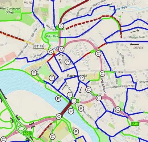
Through the years, I have come to a level that I can call myself a professional cycling infrastructure consultant, able to draw up independent reports and long-term visions, complete with artwork (such as shown on the map above) and general costings..
 This journey started back in 2007, when I learnt about GIS (Geographic Information Systems) at Ordnance Survey in Southampton, where I briefly worked as map editor. It didn't take long before I was involved with Cycle City Guides (now named Four Point Mapping).
 Between 2008 and 2011, I explored many urban areas by bicycle on their behalf, collecting data for the National On-line Cycling Route Planner, the Sustrans Route Planner and many urban cycle maps and Sustrans Cycling Maps. I analysed traffic flows, searched/developed back-road routes and often created traffic-calmed cycle routes from scratch. I did this work in cities like Manchester, Birmingham and Plymouth and in urban areas like South Staffordshire, Hertfordshire and Torbay.
Using my background as a "Cycling Dutchman" (having experienced the change in Dutch road layouts in favour of cycling first hand through the 1980s and the 1990s) and with lots of experience regarding cycling and surveying in the UK, I am probably one of the few who is truly able to translate "Dutch designs" into the UK world.

, please drop me an email on either or .
Popular Cycling Dutchman blog articles explaining Dutch cycling infrastructure:
Cycle paths and cycle lanes; the full story!
Sharing the road or segregated cycle paths? Well it is both!