Yes, the mammoth task is completed! After six years of cycling and surveying, both professionally and just for fun, I can now proudly present the London-Land's End Cycle Route Book, featuring indeed the very best traffic-calmed cycling touring routes of southern England.
The pannier-pocket guide features 1200 kms (940 miles) of routes, 140 maps (for both urban and rural areas), 500 listed facilities (like bike repair shops, camp sites, hostels and Bed & Breakfasts), detailed directions with local knowledge all the way and a fully continuous enjoyable route (overcoming gaps in Sustrans' National Cycle Network). GPS-tracks, route updates and social media for users are available via the designated website.
I hope this book will inspire people to take up cycle touring for many years to come, whether you are a passionate individual cyclist or would like to head out by bike with for your loved ones. The guidebook easily allows you to cycle shorter route sections and naturally caters for that one big cycling adventure! Parents will find many route sections extremely suitable for their younger children and can indeed take their teenagers on that special family holiday which will spark everyone's imagination, generating fond memories which will last for ever!
As you see on the map, the book not only caters for UK-cyclists, it also invites touring cyclists from the continent to go for a cycling holiday in England. Routes from both Dover and Harwich head for London to join the main route there. In Devon you can head for the ferry to France from Plymouth, allowing you to cycle around the English Channel! You can also use the guidebook to connect to the Cycle West Routes in France.
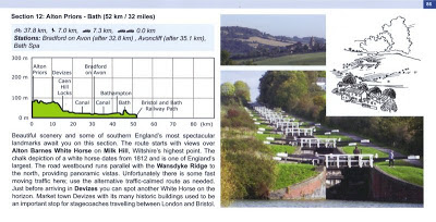
So, what is this book like then from the inside? Well, the book features 24 route sections and every individual section starts with an overview of the characteristics of the route section. You'll see how much distance you'll cycle traffic-free (35%; bike symbol) and how much distance you'll cycle on very quiet roads (58%; bird symbol). It also shows you how much distance you actually have to deal with any traffic (6%; symbol of one car = road with some traffic flow, 1%; symbol with two cars = main road on which an adjacent footpath is always available). The overview also shows all stations on the way (60 in total), so you can plan where to hop off and on trains. An elevation chart gives you a good idea about the terrain "to be conquered". Local visitor information, combined with attractive pictures and beautifully drawn line-drawings by artist Tom Pick from Sweden give you a further feel about the route ahead. An example of such a page is shown above.
Another important feature of the guidebook are the full directions for the whole journey. Note this is only provided for the east-west cycling direction. The "telegram"-style with symbols and abbreviations (full overview included in the guide) is written in such a way that you actually don't need to be able to read the maps. You can always see at a glance how far it is to the next village, town or rural pub/cafe. For reasons of clarity, all distances in the guidebook are in kilometers. All way points of the directions are also marked on the maps. The book features various map scales to be able to deal with both rural and urban areas. Above a sample of a rural page, below a sample of an urban page.


You can read an extensive route summary on the designated website, which also features a picture library with over 200 pictures. The retail price of the book is £15.99. If you order the book through the official London-Land's End Cycle Route Book website you'll have to pay an additional fee for postage, but you'll also receive GPS-tracks of the routes for free. GPS-tracks are worth £10 and can be ordered separately. I hope you'll be out on your bike soon; feedback on guidebook and routes are very welcome via the Official Guestbook or Twitter on @LondonLandsEnd.

Another great book with the same format is Cycling in Amsterdam and The Netherlands - The very best routes in the cyclist's paradise. It makes you travel beyond Dutch cliches like clogs, windmills and the Amsterdam red light district, allowing you to truly explore the lowlands. The book features 1064 kms of routes and has special chapters explaining the unique Dutch cycling-minded traffic rules and its cycle route signage systems; 164 pages, colour, wiro bound, fits in standard handlebar bag, see also http://www.cyclinginholland.com.
Other popular blog articles by Bicycleandtour.com:
Explaining Dutch cycling infrastructure:
Dutch style bike rides in the United Kingdom: