
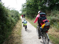
My Dutch language guidebook Heart of England Route is currently taking various flocks of Dutch cyclists from Harwich's port to the Olympics and Paralympics in London, including https://ebac.mx/blog/tecnologia-de-la-informacion a group of blind tandem riders (picture courtesy of Zizoz). This route takes them through the Essex countryside. Cyclists travel to the Olympic Park via my own route through the London districts Chigwell Row, Seven Kings, Barking and East Ham. This is just as well, as the official Sustrans National Cycle Route from the North into London through LeeValley is partly closed due to security issues during the Games. If you are interested in my traffic-calmed route from Harwich to central London (bypassing the LeeValley), please note my new London-Land's End guidebook will include this link, just as a route from Dover to London (available spring 2013). GPS-tracks will be available too!

Further afield, my wife had been able to get hold of tickets for the Olympic sailing in Weymouth. Being a proper Dutchman, I convinced her that parking at the edge of town to cycle the last couple of miles to the Olympic venue would be the ultimate way to take in the Olympic vibe. My wife remained sceptic, but after I showed her the Weymouth Cycle Map she agreed. Coming from the West Country, we took the scenic coastal road from Bridport to park at the west end of town in Chickerell.
Putton Lane
showed to be our perfect "Park & Cycle" transfer; plenty free parking and direct access to the Weymouth cycle path network. With another cycling family unloading their bikes in the same street too, we were clearly on the right track!

The first section of our 4 mile route took us on the cycle path on
Granby Way
. The new look of both path and signs indicated this important piece of west-east cycling infrastructure has been put in recently, possibly as part of an Olympic "boost". Our five year old son whizzed along the track and we encountered various other cyclists on this good flat valley route. There were even some cyclists with racing bikes, who also preferred the path above the main carriageway with its fast moving traffic. With the only hazard being some driveways (there was indeed one driver turning on high speed across the cycle path into a driveway) we are happy to award Dorset County Council their first silver medal!
At the end of
Granby Way
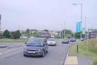
, a multilane roundabout was ahead of us, with a difficult crossing over the busy
A354 Weymouth Way
right next to the roundabout. Being a cycle route consultant I see this type of crossing all over the country. Unfortunately, to be able to cross, you have to scan the whole roundabout area for fast turning traffic, heavily depending on drivers doing proper signalling before leaving the roundabout (and many don't!). We had to stand on the island in the middle of the road for at least 5 minutes before we found a gap in the traffic, and still, we were depending on traffic on the roundabout to slow down for us to make the crossing safely.

This shows how cycle path crossings next to multilane roundabouts are NOT advisable and extremely hazardous. To make these crossings suitable for users of all ages and abilities you really need either toucan lights (please with only one press on the button and one wait to cross both road directions) or priority for cyclists Dutch style. Sorry; no medals for the local authorities at this crossing!
Once across the A354, a fine gravel route along the estuary to Weymouth town centre made pleasant cycling to us. With cycling growing in popularity, this path is close to its capacity limit though. Various cycling commuters from the Southill area were overtaking/approaching us on high speeds and we can imagine number of conflicts between users are likely to grow on this narrow path. Being it a main corridor to the town centre, also popular amongst dog walkers, this path should be ideally 4 metres wide or more, with ideally segregation for pedestrians Dutch style. In its current setting, a cycle path is better than nothing, so our jury finds a bronze medal for this stretch applicable.

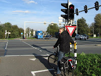
The next junction en route, the roundabout at the river bridge, with various cycle path underpasses, was adequate, but lacked one important aspect of cycle path infrastructure; good and consistent signage. An incorrectly aligned signpost made my wife ready to join a route leading away from the Olympic venue, a perfect example of how poor signage is a continuous problem in the UK. In my cycle report for Totnes I emphasised on the importance of Dutch style consistent "A-to-B cycle route signage" to get more people familiar with local cycle routes. Free town cycle maps and on-line route planners, how well intended, only serve those who are into map reading (like me). It is only for this reason we were able to find the next section of our route. So, on this occasion; good infrastructure in combination with poor signage only justifies a bronze medal.

Once we found it; the Rodwell Trail really lived up to its promise. It is an excellent cycle route on the course of a dismantled railway with good tarmac surface and a great mix of scenery to take in, appealing to both locals and visitors. The Sustrans Connect2 project made a new bridge possible across
Newstead Road
, clearly improving the attractiveness and speed of travel on this route. Also, there are many slip paths to connect to the local road network, a great help for local connectivity. The jury was ready to award the first gold medal for Dorset County Council, but then there was one complication…


So, what about the cycle-friendliness of the venue itself then? Now, here we were really up for a pleasant surprise. The Olympic organisers had gone to great length to provide a guarded bike parking in Dutch style next to the main entrance, and even FREE to use. Having that said, with the difficulties we experienced to reach the site, it should be! Finally, the jury could grant Weymouth a gold medal for their sustainable travel efforts. With many bikes already in the cycle racks, it showed how more and more people in the UK are trying to make a sustainable effort to get around by bike.

Looking at the crowds present on Nothe Hill though, those who cycled to the Olympics were still in the minority by far. To get more people on bikes, the issues as addressed above need proper attention. I found the general Weymouth situation exemplary for areas with good cycling efforts around the UK. But even in these "better areas", away from the existing cycle routes, cycling as a way to get from a to b remains in its infancy. A strategic approach is needed to make cycling a good means of transport for people of all ages and abilities, everywhere. The Cities Fit for Cycling Campaign provides a good starting point and I am more than happy to oblige. Overall cycling infrastructure medal results for Weymouth: BRONZE!
What about getting on your bicycle yourself with one of my "Cycling Dutchman" guidebooks?
 Cycling in Amsterdam and The Netherlands - The very best routes in the cyclist's paradise makes you travel beyond Dutch cliches like clogs, windmills and the Amsterdam red light district, allowing you to truly explore the lowlands. The book features 1064 kms of routes and has special chapters explaining the unique Dutch cycling-minded traffic rules and its cycle route signage systems; 164 pages, colour, wiro bound, fits in standard handlebar bag, see also http://www.cyclinginholland.com.

Cycle paths and cycle lanes; the full story!
Sharing the road or segregated cycle paths? Well it is both!

 Dutch style bike rides in the United Kingdom:
The London - Land's End Cycle Route Book is designed for those who LOVE cycling, but don't like traffic. The book takes you onto the most beautiful cycle routes of southern England, including the Camel Trail, Devon Coast to Coast Route, Bristol and Bath Railway path, Thames Valley route and many more! What makes the book unique is that the route is completely continuous, including detailed directions and local knowledge all the way. Get inspired; choose your favourite route sections or go for a full summer holiday adventure; 164 pages, colour, wiro bound, fits in standard handlebar bag, see http://www.london-landsendcycleroutebook.com.
Other popular Cycling Dutchman blog articles:
Other popular Cycling Dutchman blog articles:
Explaining Dutch cycling infrastructure:
Cycle paths and cycle lanes; the full story!
Sharing the road or segregated cycle paths? Well it is both!