
Totnes is a small thriving town in southern Devon. As recently shown in the BBC's "Town" programme, its people are at the heart of the TransitionTown movement
, which aims to solve https://ebac.mx/autocad environmental and social problems of our world on a local level. Recently, Devon County Council made Totnes one of the hub towns for its Local Sustainable Transport Project. This is a great victory for Totnes on the Move, a unique community-led campaign to reduce carbon emissions and to make local infrastructure work better for local people. They recently ran their first road show where residents could actively engage in proposals to improve conditions in their town.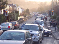
Action is needed. Totnes provides one of the few traffic corridors for those who wish to travel in and out of Torbay, a large urban area of over 130,000 residents. Totnes is also on the main route to the South Hams peninsula. With the Totnes locals making their own journeys too, it is not difficult to imagine how the town gets hammered by motorised traffic on a daily basis, with few options available for those who wish to make local journeys on foot or by bicycle.
I was honoured when Totnes on the Move hired me as an external consultant to write their Integrated Cycle Plan as part of the Local Sustainable Transport Project. I had previously advised local authorities regarding their cycling infrastructure as part of my surveying work for Cycling England, but this was the first time I was asked to do a full comprehensive study about the long-term potential for cycling in a specific town.

The 200 page report I have produced contains over 400 pictures and is probably the most extensive independent local cycle network study ever written for a town in the United Kingdom. It identifies the main traffic corridors for cycling in a town and to/from its neighbouring villages. It also provides a long term vision with 5 phases of implementation of the network. The report provides detailed infrastructure and signage recommendations for every phase.


Most importantly, 30% of the report consists of a full signage plan. Consistent and clear signage is one of the most important keys to the success of the Dutch cycling concept. It allows people to make day to day journeys by bicycle without the need for extensive knowledge of an area, always bringing users to the doorstep of their destination (see picture). If implemented in Totnes, it would be for the very first time in the UK cycle route signage gets really taken seriously, with a likely boom in cycling participation as a result. At the moment, many people who'd like to take up cycling just don't know the way to go!

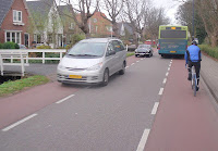
Another important Dutch cycling concept is forced priority for cyclists over turning traffic on cycle path crossings parallel to main roads. On most UK cycle paths, turning motorised traffic can proceed at will on high speed, even when turning in and out of private driveways. This makes the use of cycle paths parallel to main roads often more hazardous than cycling on the main carriageway itself, an important reason for many cyclists to ignore these paths. I've recently spotted a good example in Central London of how the concept of forced priority for cyclists could be implemented in the UK (see picture left).
Also relevant for Totnes, and especially for its own old bridge between the town centre and the Bridgetown area, is a Dutch forced Share the Road Layout, on which centre lines are removed in favour of wide cycle lanes (at least 1.5 m wide!) on both sides of the road, removing the visual suggestion to drivers that roads are just built for them. Thousands of miles of Dutch roads have been successfully converted to this model. You can read more about this in my blog of December 2011 or in my Cycling in The Netherlands Guidebook.
It is important to understand that a good cycle network consists of a combination of concepts, which are supplementary to each other. For example, to make the Dutch Share the Road Layout work on the old TotnesBridge, additional traffic calming to reduce the current motorised traffic flow is needed as well. This can easily be achieved by limiting turns from/to the main road into town. This concept gets currently occasionally introduced in various places in the UK.

(Note from the author in 2015: Unfortunately, my plan has ended up in one of those many drawers in council offices. All what has come of this project is that a section of High Street in Totnes has now a one-direction flow in the opposite direction as it used to be (I didn't dare to suggest such a change in motorised flow in my plan!). This course of action has stopped trough traffic through the High Street and it is still subject to local debate. Meanwhile, cycling in Totnes is still something for the very few...)
What about going for a traffic-calmed cycling holiday with one of my "Cycling Dutchman" guidebooks in a country where cycling gets taken seriously?

Out of reach of Totnes, but getting pretty close:

The London - Land's End Cycle Route Book is designed for those who LOVE cycling, but don't like traffic. The book takes you onto the most beautiful cycle routes of southern England, including the Camel Trail, Devon Coast to Coast Route, Bristol and Bath Railway path, Thames Valley route and many more! What makes the book unique is that the route is completely continuous, including detailed directions and local knowledge all the way. Get inspired; choose your favourite route sections or go for a full summer holiday adventure; 164 pages, colour, wiro bound, fits in standard handlebar bag, see http://www.london-landsendcycleroutebook.com.
Other popular Cycling Dutchman blog articles:
Other popular Cycling Dutchman blog articles:
Explaining Dutch cycling infrastructure:
Cycle paths and cycle lanes; the full story!
Sharing the road or segregated cycle paths? Well it is both!

